
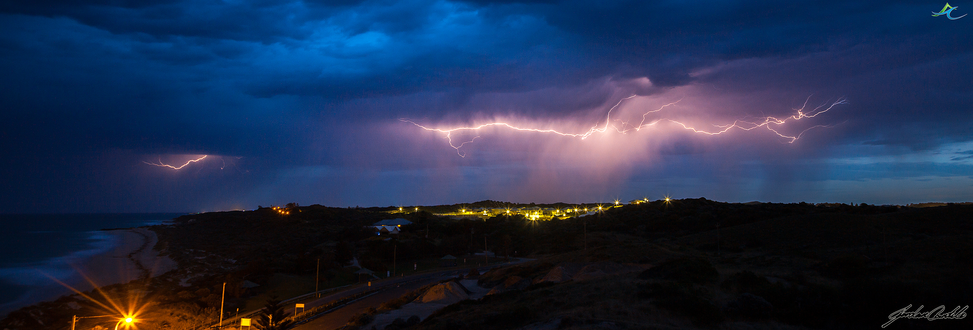
Spring Cold Fronts

After a beautiful taste of spring weather of 34C yesterday in Perth (a new September record), we were brought back down to reality with a bang today with rain and a very cold change coming through, thanks to a vigorous cold front that came across the coast in the SW of Western Australia.
Here it is just as it was just about to go over me at Jindalee Beach.

– Late Wet Season Storms –
Isolated late wet season storms fire up just off the NW Kimberley coast. It’s incredible how quick these tropical systems fire up and explode into the sky. Blue skies one minute, the next, thunderstorms, however one thing that doesn’t change are the ever magnificent turquoise blue waters.

Late Wet Season Storms hit the North West Kimberley
The past week I have been fortunate enough to be flying around the NW Kimberley region of Western Australia and being witness to some late wet season storm activity. I haven’t seen tropical development of storms too much in the past, so this was a real eye opener, and being up in the air just added to the drama of it all.
This cell was clear air underneath only minutes before, then the heavens opened, and this is what was in front of us.

Cumulonimbus cloud like this were skyrockets right up into the troposphere. A terrific sight to witness.

Another cell dropping rain over the Mitchell Plateau

The weather was very humid and hot, and I was told these were the typical conditions you would expect during the build up before the wet season begins. My work colleague Ed has lived up here for a while and knows that days on end of these hot, humid conditions that something is going to happen. On the final night of staying at our camp, the heavens opened and the lightning started from the south and moved very slowly directly over us. Lightning was all around, it was like I was at a nightclub with the strobes on full bore. I haven’t seen lightning like that for a very long time, so you could imagine I was like a kid at a candy store.
Storms starting to build just on sunset

The red glow of distant fire with another approaching thunderstorm

A very close bolt of lightning near our camp, completely blown out my exposure.

Another reasonably close bolt just south of the camp.

Lightning striking just to the north of the camp

The explosive cracks of thunder were incredible, the storms produced a lot of sheet lightning, of which seemed to have been occurring right above our camp. It was out of this world, and since it was the first decent thunderstorm I had seen for a couple of months I was on cloud nine seeing lightning and hearing it crash and bang around me.
Until next time……
Lightning at Last

FINALLY!!! As with many of you, we woke this morning to the magical sound of thunder. Woohoo.
I thought I had missed the boat, but just after 6am a cell decided to redevelop over my place in Butler.
Stoked to have got this shot, with no lightning trigger and handheld! Woohoo! First lightning shot with the zeiss!
Bring the storms!
Another underside shot from this morning.

Perth’s first Summer Storms
Well they are here, Perth’s summers storms have finally arrived. The very photogenic, high based, branchy lightning that I love capturing started striking north of Perth just before midnight, so I made my way to Jindalee with fellow photographer and weather nut Cameron.
We saw the storms staring to spark a long way to our NW, so we held steady until they got a touch closer, and then made the decision to get off our hill, and down to the sand-dunes. A good move as the storms came right over the top of us, and our spot on the hill probably wasn’t the safest place to be.
I love to capture lightning, but I really like to place subjects in my shot, just to add a different dimension and perspective to it. So I got Cameron to hold steady and composed a shot I hoped would come out, I just needed the lightning to co-operate.
It did, and I managed these shots of Cameron in his element.

And this one,

A majority of the storms were relatively short lived, but they produced some incredible lightning.
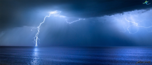
Off the coast, my favourite shot of the night.

It just kept producing amazing bolts. The hardest part, anticipating where the big strike will strike.

More amazing branchy cloud to ground lightning,

The boats off the coast, were in the prime location to view the storms. Saying that, I don’t know if I wanted to be under this one.

As the storms moved over us, we made the decision to move east of the Pinjar pine plantation to try and capture a cell now moving quickly down the Darling Scarp, but the storms were just a bit too fast and were moving to the SE very quickly. Checking the radar, they were hooking through at around 70-80kmh, too quick for us to catch them.
I fired one last shot off before calling it a night.

Until the next time….
All official forecasts are from Bureau of Meteorology.
Check out PerthWeatherLive on Facebook for updates on the weather around Perth and Western Australia.
Early Morning Spring Storms over Perth
Storms impacted the northern suburbs of Perth Sunday week ago and into the early morning hours of Monday.
The charts showed a good chance of storms to fire up to the north around dusk on the Sunday, which in turn had me bolt up to one of the fire lookout towers north east of Two Rocks. On arrival I could see very nice structure a long way to the NE, but knowing that the storms should develop closer during the night I decided to stay put.
I did however capture this shot of the lightning that was striking down to the NE of the fire lookout tower.

As the sun set, I decided I would head home to get some gear ready for the long night ahead.
I checked the radar around 1030pm and saw a little bit of development a long way to the north, so I contacted another mate and it was decided that we were heading up to his lookout near the beach, just incase the storms really did decided to fire up. We wanted to capture the show.
Over the next hour nothing really eventuated, but we thought it would be a good idea to head just a bit further north to Yanchep in the hope that if the storms did fire up, we would be just that little bit closer. So we packed up, and drove the 20kms to the north and set back up again, waiting in anticipation for the following radar updates.
As midnight came closer, the mood was turning south. We could see now development, bar a couple of odd echoes on the radar, so I decided to call it a night. So as I was just about to start packing my gear up to throw in the car, a strike occurred, a little bit to the north along the coast, but a strike none the less.
I unpacked my tripod again, and set up. Now started one of my best nights yet of lightning photography.
The storms really started to fire up, the radar started now to show a little bit of colour, it was GAME ON!
The storms really started to throw out some great photogenic lightning. Very close branchy cloud to ground strikes to our north and slowly to our NE.
Here are a couple of captured as the storms got close.
Due north along the coast


Due east

After taking plenty of shots as the storms developed and fired off to the north and north east, I directed my attention to the storms now firing to the south.
Rockingham was now in the firing line, and they were certainly in for a great show if any of these bolts were to go by.

Facebook’s Perth Weather Live founder and mate Steve Brooks was there, he said “I was watching the cells build on the radar to the NW, but stuck it out at San Remo. Between 2am and 3am I was greeted by some of the best metro sparks I’ve had in quite a while”.
From what I could see they got an incredible show.
Back to the north now, and the storms still fired right up through the morning sunrise. Here are a couple of shots as the sun started creeping towards and over the horizon.


The night was incredible, spent with another weather nut Cameron Fisher. We were both in awe the whole night, and then to be greeted with the most stunningly vibrant sunrise with fluorescent lightning sparking all around. It was one of the scenes that I certainly will not forget in a hurry.
I cannot wait to get these images printed.
Until next time………………….
Links
Jordan Cantelo Photography (Facebook)
Woz Storms (Facebook)
Perth Weather Live (Facebook),
Perth Weather Live (Web)
Storm Event 6/7-9-13( Gascoyne, Wheatbelt, Lower West)
The most promising setup for thunderstorm development since last summer was forecast for most of the southern half of Western Australia on the 6th of September, and that prompted a certain trip for myself to again get out and try to capture this magical weather phenomenon on my camera.
Just over a week before the storms arrived I noticed on my daily check of forecasted weather that I should start preparing for a road trip up towards the lower Gascoyne region to capture my favourite part, the development.
My day started at around 1030 with a drive to Coorow via Bindoon and the Bindoon Bakery. No storm chase can start without a stop here. So after enjoying a curry lamb pie, I was off up the Great Northern Highway towards Midlands Rd and on to Coorow via Moora.
I arrived in Coorow just after 1330, and had another look at the radar, and satellite imagery to see if anything looked like it was going to develop in the area. I wasn’t in luck, with storms started to fire a long way east on a low pressure trough line cutting through the state. I didn’t worry to much about it, as the afternoon was young, and it gave me a bit of time to scout the area a bit. I am currently working on a time-lapse project and the fields around here work perfectly for one of the scenes I wanted to capture, so off I went to find one suitable for my project.
I found an incredible site and set my camera up and started my time-lapse of the clouds building and collapsing. I had some more time up my sleeve now as my time-lapse was set for 1hr, so I had a bit of a walk around playing on my iPhone.
Coming close to the end of my time-lapse I noticed some development a long way to my north and north-east, so I opened my laptop and again checked the lightning tracker, and it confirmed a major thunderstorm developing very quickly between 150-200km away. I was in two minds, either packed up my camera, stop the time-lapse and move now, or wait for the time-lapse to finish. I decided to wait, as I only had 10minutes or so remaining, but it was the longest 10minutes ever. I was pacing up and down the road, watching these thunderstorm cells popping up and going crazy. They were too far away to see any lightning, but they were large cauliflower clouds with an every increasing anvil spreading across the sky.
My time-lapse finished, I packed my gear up and raced east towards Latham.
I kept my eyes on the development, and I had to pull over near Latham to capture one of the storms.

As I got to Latham, I had to turn south and now head towards Wubin for fuel, and to meet with fellow storm chaser and friend Steve Brooks (owner of Perth Weather Live, http://www.perthweatherlive.com).
I arrived in Wubin, and met with Steve. He had been watching the cells to the north as well, so with a quick check of the radar to see the direction these cells were going, we saw that they were going to cross well south of Paynes Find to the north, and so the decision was made to get north, and find a spot to set up and capture these systems as they passed us by.
While we were driving the sun started to set and the thunderclouds become illuminated with incredible colours. It was incredible to witness. We were so focused to get to our spot that we missed the opportunity to capture the sunset at its best, but, we still still got a bit of colour and you can see that how it would’ve been incredible 5-10mins before hand.

When we arrived at our location, we set up and started to capture the storms in the distance. One was to our North-East, one was t our North-West. Both were firing on all cylinders. Flashing, and sparking everywhere. Every second multiple strikes illuminated the clouds. So what did I do. I set up my time-lapse to capture it. I havent finished processing that yet, but when I do, I will post a link to the page it will be hosted on.

Then the night really began.
A shot of a meteor flying over first cells of the night to the north.

As the first cells passed over and headed east, the skies to the west now started to light up. Cells were quickly developing to our west, and were going nuts!!
A shot of the Milky Way with the storms firing underneath.

Large amounts of rain mixed with hail were falling from incredible formations in the clouds.
Something about the structure I just love underneath thunderstorms.

Lightning was all around

One of the final cells that passed over before I had to make the long drive home.

I had to leave, as I had to get back to Perth. The drive home was very eventful. Large hail, strong winds, lightning all around.
An extremely eventful night, but I am so glad I was able to witness it, and not on my own either. Cheers Steve, it was so great to have someone else there, yelling out as much as I was!! 🙂
I just hope this is an indication of a very active spring/summer storm season in the Midwest and Wheatbelt.
More photos to come.
Till next time.
Strong Cold Fronts, Perth, July 26th 2013

Yesterday (26/7) a series of strong cold fronts impacted the Western Australian south west coastline.
Not one to shy away from the opportunity to get a few photos, I thought it would be a good chance to capture a bit of colour at sunset.
Just my luck, as when I arrived another cell was about to cross the coast just to the south of my location at Jindalee.
I was in the best position to capture it, just before it impacted the coast. The system intensified as it neared the coast and bought with it very heavy rain, hail, and strong winds.

This second photo is the same system as above just before it crossed the coastline. You can see how the rain sheet has intensified from the previous photo.
Later in the night, another series of storms swept through the northern suburbs and right over my place.
I don’t usually travel during these events, as 1) they are too dangerous to travel in, strong wind, heavy rain, and hail making driving very hazardous, mixed with over traffic. No thanks!, So when they come to me, I can just set up in my garage, and point my camera to the sky.

This time, I had a strike very close to me, and the thunderstorm ripper right over my head. As soon as this cloud to ground strike occurred, the loudest, most explosive thunder clap I have heard for a while shook the house.

It has got me wanting the spring and summer storm season to hurry up and arrive so I can head out to the Wheatbelt and capture this magical phenomena once again.
Stats from this cold from event.
( From the Bureau of Meteorology, Australia)
A wind gust of 102 kilometres per hour was recorded at Ocean Reef at 7:30am.
A wind gust of 91 kilometres per hour was recorded at Rottnest Island at 12:21am.
– Tropical Storms in Bali –

One of the best things about visiting the tropics are the amazing thunderstorms that tend to just pop up out of nowhere.
After watching a bit of cloud build up just to the north of Kuta, I raced up to my room grabbed my gear and then set up my camera to time-lapse the developing cells.
After not being able to get to Darwin last wet season, I might just make it this year. Here’s hoping 🙂
The Cold Front Approaching Perth 19-5-13

Another cold front crossed over the Western Australian coast tonight. A few nice thunderstorms accompanied it. When I arrived to capture photographs, this is what greeted me.
The full moon was illuminating the clouds from above and the stars were out.
I couldn’t resist myself, but to get a panorama of it all.
Tonight was by far the coldest I have ever been taking photos of thunderstorms. Lucky I had a big woolly jumper on.
Autumn Storms over the South West 16-5-13
I was woken this morning by the deep rumble of thunder in the distance.
I am usually rather lethargic getting out of bed in the morning, but that beautiful sound that is thunder, I am up in a flash. I was dressed and ready to head out within a few minutes.
When I glanced outside, the early morning rays of the sun were just touching the base of the clouds. I raced down the stairs of my hotel room, jumped in my car and got to the beach.
This is what greeted me.

With reports from the Yallingup area that the storms were dropping water spouts behind me, I had to make the trip towards home.
The potential for storms to still fire into the night was still there, so with that in mind, I headed to Jindalee beach once I finished work and managed to capture this strike.

The lightning wasn’t very frequent, so I am somewhat happy with this, because it was the best shot of the night.
I do love every type of thunderstorm, but the summer ones where I can chase them around the Wheatbelt region are far more enjoyable, and you can get a hell of a lot closer.
Bring back summer already.
I hope you like the images.
Goomalling Lightshow
On the 6th of January, I was lucky to witness one of the most active storms of the summer season here in the Wheatbelt region of Western Australia.
I had thought I had lost these images after accidentally misplacing them while transferring the files off my camera. Thank god I did a random search through a few folders on my computer and found them again. I hope you enjoy viewing them.
-Electric Skies-
As you can see, this particular storm out in the Wheatbelt provided ample opportunity to us to capture lightning. The activity was out of this world.
This is what I love to capture, and all I can think about is getting out to the next system and capturing it.
I think I’ve found what I want to do.

-Active Strobe Show-
This particular night was so active, incredibly this is just a 30s shot. The bolts were coming down everywhere. The winds just in front of this system were very strong, at one stage I had to hop into my car, and hope to god my camera rig was sheltered enough not to get knocked over.
-Forked Light-
The cloud is the way it is, due to lightning strobing through the cloud during the exposure. One strike would illuminate the cloud in its current position, another strike several seconds later would freeze the cloud in that position, resulting in the effect you see here.
You can read the full chase report of the day HERE.
—————————–
All photos used on this site severewatherphotography.wordpress.com, severeweatherphotography.com.au, jordancantelophotography.wordpress.com & http://www.jordancantelo.com are copyright and are the property of Jordan Cantelo. Strictly no reproduction or commercial use allowed without prior approval.
Photography website limitations.
Please Note: The best care has been taken to accurately represent the finished photograph in the online gallery, however due to web limitations and differences in individual user’s monitor settings, printed photograph colours may differ slightly from the photographs viewed on this website.
Storms over Perth

The first major cold front of 2013 hit Perth today, bringing with it thunderstorms with strong winds and heavy rain and even hail in some locations.
I was lucky to get this shot, as every time I set up, another rain shower would open up on me. A couple of failed attempts and I managed to get what I was after. A storm over the City.
Central Wheatbelt Storms 16-3-13
It’s that time of the year again when thunderstorms start to develop and make their way over the Wheatbelt region of Western Australia. Today marked my first Autumn trip into the Wheatbelt and with a severe weather warning issued it was set to be a big day.
Initially the storms were forecast to be about the Perth Hills by mid afternoon and then track east. I wanted to capture the development and again some structure so I thought I would base myself away from the movement of the storms and head towards Goomalling, a small country town about 150km NE of Perth. This area is usually the prime spot for development, but it also has good access in all directions, so it’s a good place to re-access your plan of attack.

So I arrived in Goomalling, and storms were already developing and maturing a lot further east then they were forecast to. So I refuelled my car, and headed toward Dowerin, then Wyalkatchem, onto Trayning, then finally ended up in Nungarin, just as the show was really starting to fire up.

Seeing the storms structure during the day is incredible, and I love capturing that, but at dusk as the sun is setting, that twilight time when the lightning is now illuminating the clouds, that is magical. The sky was clear above me with stars starting to appear, but to my east, the best strobe show I have seen for a long time was occurring, it was breathtakingly beautiful. I set up my camera and proceeded to capture my time-lapse that I had come to get.
The lightning was unbelievable, and I even managed my first ever capture of lightning coming out of the top of a cloud.
As the storms moved further to SE they did not loose any momentum, and if anything they might have started to get more active. It was a strobe show, like none other I’ve seen before. A line of thunderstorms in perfect harmony, all linked and firing off. It was incredible to see.
As I moved my camera to face the cells moving further away, I started to notice a feature low on the horizon that looked very suss. To me this looked like a tornado, but it could’ve quite realistically been just low scud cloud that was arranged in a way that made it look like one. Maybe, maybe not. We will never know, because out here luckily, we are very sparsely populated.
Here is the photo, and leave a comment to let me know what you think.

This is my track map for the day, thanks to Google Maps. A total of 650km for the day, not that far by any stretch and definitely not the furthest I have travelled chasing and photographing.

I am currently processing more images, time-lapse and video (I got some rotation in a cloud that looks amazing on GoPro) of the night, and that will be posted in the coming days.
I recorded a live stream while I was out there, and you can hear it here
http://www.ustream.tv/recorded/30019393
A small video I created of time-lapse from the day, watch in at least 720p HD
Till next time 🙂
Lightning Approaching

A lot of people know that thunderstorm and severe weather photography, is what I love, but daytime lightning is starting to become a favourite subject of mine.
To incorporate it into landscape photography is very rewarding.
Lightning over the Pines

Thunderstorms were forecast for Perth today, but were not forecast to develop until mid afternoon. That was not to be and as soon as I was awake at 630am, the rumbles were well and truly underway.
Daytime lightning photography is quite tricky, so I am stoked with this photo.
Plenty more to come, but they will have to be posted tomorrow and over the weekend.
Lightning over Jandakot and the Perth Hills

On Wednesday (20th, Feb) I headed to Jandakot Airport for a bbq with fellow workmates. The night started as any other, something to eat, a couple of drinks. Then the clouds started rolling in. Lightning began flashing on the western horizon and it wasn’t long till it was over us. I headed to the lookout, and set up my camera. The lightning tracked just to the south and east of the airport, providing a great opportunity to capture a few shots.

Lightning, just cannot get enough of its beauty. No single strike is ever the same, and it truly is a genuine shot. No-one else will ever capture the same strike again.
Hope to capture more as I head north to Port Hedland next week.
Wheatbelt & Perth Storms 6&7-1-13
On Sunday I headed out to the Wheatbelt region of Western Australia to again chase down a few thunderstorms that were forecast to develop in the area during the afternoon. And form up they did. I headed off from my place in the northern suburbs of Perth at around 1215pm and drove towards the town of Brookton. As I headed down a highway towards Brookton I encountered very heavy rain about 15km from the town, heavy enough for me to almost come to a complete stop for 30s. It was a crawling pace, but only last for a short while.
I got to Brookton at around 1445, and refuelled. I had received a call just prior to arriving from fellow chaser Tom, who said that he was going to try and get in front of a system that was already forming just SE of town, so after refuelling I checked the radar and realised that Tom was on the money, the system that he was chasing was developing quickly.
Not one to wait around, I headed south towards Pingelly, and then east towards the town on Yealearing. I found myself about 5-10 minutes too late, the storm was already over the town, and I had no other choice but to try and core punch the system to get to the other side (something I do not recommend trying, and something I always try to avoid). The result would’ve been a few spectacular photos. I know this because Tom was able to get in front of this cell and capture the most defined wall/shelf cloud I have seen for a long time.
Feeling a bit down because I had driven a few hours to get here and missing the shot, I was still very keen to stay out and try to get a few shots. The forecast wasn’t the best, so I had made the decision to head towards the town of York and try my luck at some star trail time-lapse for the night. Though my luck was about to change. As I was heading towards York, I could see on the northern horizon a series of cumulonimbus clouds exploding into the air. So I pulled over for a quick look at the radar, and it confirmed a thunderstorm was in fact starting to build to my north by about 75km. So that is where I headed, towards the town of Goomalling, and then onto Wongan Hills.

I didn’t make it to Wongan Hills as the storm was well and truly firing by the time I got close. The lightning was very frequent, and when I got my camera set up, I was capturing at least 2-3 strikes per 20sec in frame, (out of frame easily 5 more). It was an incredible lightshow and it was going to fly directly over me.
I set my camera up as quick as I could and hopped back into my car, just in case a stray bolt decided that I was going to be a target on this night. As the storm got closer the winds picked up tremendously, with gusts easily in excess of 100kmh, I struggled to get the camera back into my car. My car was shaking around, and I knew I had to get further up the road and away from these gusts.

As I pulled out from the edge of a farmers paddock, I was lucky enough to bump into fellow chasers who were chasing this particular system earlier on.
We all headed back towards Goomalling and watched this system fire of lightning like there was no tomorrow. An incredible sight.

The system continued for another 45 minutes or so towards Goomalling, before tracking slightly more to the SE towards Cunderdin, the storm weakened rapidly and we headed off.

On the way home, I checked the radar one more time, and low and behold another couple of cells were moving down the coast from Geraldton. Knowing I had the Monday off work, I got in contact with another chaser/photographer who was out in the wheatbelt to see whether he wanted to stay out and wait for these storms to come to us. We met up in Yanchep, and the cells tracked straight down the coast passed Jurien Bay, Lancelin, Guilderton and then onto Yanchep. I didn’t have my telephoto lens, so I decided that I would time-lapse the approaching storms.

The second and final cell went over our heads at around 0530am.
The radar showed not too much more development was in behind these cells, so I headed home exhausted, but with a card full of very cool shots.
I travelled a total of 890km for the day chasing around the Wheatbelt and back into Perth. Needless to say, I loved every minute of it.
A video I put together of the chase, it features a couple of short time-lapse sequences, as well as a few photos found in this post
YouTube (Video Link)
Vimeo (Video Link)
—————————–
All photos used on this site severewatherphotography.wordpress.com, severeweatherphotography.com.au, jordancantelophotography.wordpress.com & http://www.jordancantelo.com are copyright and are the property of Jordan Cantelo. Strictly no reproduction or commercial use allowed without prior approval.
Photography website limitations.
Please Note: The best care has been taken to accurately represent the finished photograph in the online gallery, however due to web limitations and differences in individual user’s monitor settings, printed photograph colours may differ slightly from the photographs viewed on this website.
– Approaching Storms –

Last month I travelled north to capture storms that were forecast to develop around the Jurien/Coorow/Moora areas.
After a big night of lightning near Jurien, the storms started to develop further inland.
I was on my way to meet up with another storm photographer Marie and her parter Arek, when I saw this developing just to my north.
It turned out to be quite nasty when it hit, strong wind gusts, and isolated very heavy rain impacted the area, about 30km os so NNW of Moora.
—————————–
All photos used on this site severewatherphotography.wordpress.com, severeweatherphotography.com.au, jordancantelophotography.wordpress.com & http://www.jordancantelo.com are copyright and are the property of Jordan Cantelo. Strictly no reproduction or commercial use allowed without prior approval.
Photography website limitations.
Please Note: The best care has been taken to accurately represent the finished photograph in the online gallery, however due to web limitations and differences in individual user’s monitor settings, printed photograph colours may differ slightly from the photographs viewed on this website.
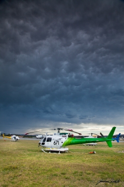
Perth’s Stormy Start To Summer
Perth usually is really starting to warm up at this time of year, with thunderstorms not uncommon to pop up in the forecast. The start of summer this year has been a relatively unusual stormy one. Not that I am complaining one little bit, the opportunities to get out and about to capture these storms has been fantastic.
The last week I have been working out of Perth Airport, so when I am not too busy, I have been able to get out and grab a few photos.
Here are a couple of shots I have managed over the last 3 days. With a few more still to be downloaded.
This shot was taken from the new viewing platform over the 03 threshold at Perth International.

This is taken at 7am out the front, with our Helitacts parked up underneath the mammatus clouds above.
—————————–
All photos used on this site severewatherphotography.wordpress.com, severeweatherphotography.com.au, jordancantelophotography.wordpress.com & http://www.jordancantelo.com are copyright and are the property of Jordan Cantelo. Strictly no reproduction or commercial use allowed without prior approval.
Photography website limitations.
Please Note: The best care has been taken to accurately represent the finished photograph in the online gallery, however due to web limitations and differences in individual user’s monitor settings, printed photograph colours may differ slightly from the photographs viewed on this website.
Perth Storms 4 & 5-12-12
The day started with the forecast of possible thunderstorms to develop to the north of Perth in the early afternoon and later impact Perth when the sun dipped below the horizon. I went into work with my camera all ready to go, just incase I was out in the field and was able to get a couple of sneaky shots. As it turned out, I was called to a couple of fires and the chance of capturing the thunderstorms during the afternoon quickly diminished.
The storm started appearing on the radar at around 10pm as I was arriving home from work, and was slowly developing and looking to tracked straight down the coast. I was quickly in and out of the shower, had all my gear back into my car, and bolted down the beach to meet up with fellow storm photographer nut Cameron Fisher. The lightning started to really ramp up as it was getting closer to the coast, with the most activity happening just off the coast at around midnight. Storms were also developing further inland, but there was no way we were moving, as the coastal cells were really giving us a great show.


Storms are again forecast for next Monday the 10th, so we are watching the charts and models to plan our next trip to capture this fantastic natural phenomenon.
—————————–
All photos used on this site severewatherphotography.wordpress.com, severeweatherphotography.com.au, jordancantelophotography.wordpress.com & http://www.jordancantelo.com are copyright and are the property of Jordan Cantelo. Strictly no reproduction or commercial use allowed without prior approval.
Photography website limitations.
Please Note: The best care has been taken to accurately represent the finished photograph in the online gallery, however due to web limitations and differences in individual user’s monitor settings, printed photograph colours may differ slightly from the photographs viewed on this website.
Feel free to comment or contact me if you have any questions in regard to the shots at
info@jordancantelo.com
Lower Central West – Perth Metro Storms
It is not very often in Perth that we are in a position to be on the receiving end of border line severe storms on almost consecutive days. (3 days apart to be exact). The storms in the middle of the week were just awesome, but they were really just a precursor to what was to come 3 days later.
Watching the charts after coming home exhausted from the mid-week chase, a few of us noticed that the weekend, particularly Saturday was going to bring a very good chance of well set-up storms.
The charts said the best place to be and where they were going to be at their most impressive was up around the Moora sub-districts at around 3pm. But as is usually the case, the storms started firing a touch earlier then planned. So I headed off an hour or so earlier then I had initially intended to.
The first place to meet was Bindoon, a small to medium sized farming town on the outskirts of the Perth metropolitan area, and home to one of the best bakeries ever. This was also the location that I would meet up with fellow photographer Glenn Casey.
After meeting up, we looked at the weather radar and realised that the storms had really started to develop. So it was a case of get to Moora, and to get there fast. While driving north we paralleled a very mature thunderstorm to our east. It was huge, and it was with no question that we pulled over to take a few photos. But knowing that this wasn’t the only storm that was going to develop for the day we jumped back into the cars and headed further north towards a farm we knew would give us great views of the developing cells.
We arrived at a canola field about 35km south of Moora, and realised quickly that this was going to be a very interesting day. Storms were popping and exploding right in front of us.
I took this 48 image panorama from the location.
-Edit-Panorama")
The storms were just firing up everywhere, one after the other. Just to the north (left hand side of the above image) a quite severe storm was developing and we thought it would be a great opportunity to catch and jump in front of it to grab a few structure shots. So off we headed, a 25km drive to the south towards New Norcia.
We pulled up just off the side of the road, about 10km to the west of New Norcia. Looking north the storms were glowing green and billowing with inflow winds easily reaching 40-50km/h. It was spurting cloud to cloud (CC) lightning and a few cloud to ground (CG) strikes, with the thunder incredibly loud. It surely was getting very close, and just as it looked like we were right in the path, the storm started tracking slightly to the SW. It was being pulled towards the coast by a developing low pressure system hanging just off the coast. It was good for us, it gave us a fantastic opportunity to get some great photos, but what it meant now, is that the northern suburbs of Perth were now it the direct line of these very intense, hail ridden thunderstorms. Hail the size of golf balls had now been recorded and all I could see now was the chance of a repeat of the devastating hail storm back in March 2010.
I shot this photo as the storm started to track SW.
")
After the storm passed to our west, it was now apparent that the storms were definitely under the influence of the low pressure off the coast, and they were heading SW towards Perth. To keep up with these storms we had to make a decision and make it quickly to what our next move was going to be. We decided to get moving as soon as possible to get towards the coast. We drove from New Norcia, through Mogumber, towards Regans Ford, and then on to the coast via north of Gingin, and finally at Two Rocks. We arrived just on sunset, and what a colourful sunset it was. With a system now to our north heading out to sea. I took this shot.
")
The winds were howling on the coast. Inflow winds to 50kmh would be a rough estimate, but I don’t think I would be far off. Sea spray was a bit of an issue trying to get a clear shot, but we still managed to get a few shots of lightning as the daylight disappeared.
")
")
In conclusion the day was quite the event. I haven’t chased a storm where it was forecast to head SE away from the metro area, to then change complete direction and put the metro area at great risk from very serious damage.
The storms were well covered by fellow chasers, all with different reports and encounters and kept live reports coming in.
I used multiple resources while chasing these storms, the official forecast and radar images from the Bureau of Meteorology Australia, Weatherzone.com.au, and Perth Weather Live ( PWL ) ( Perthweatherlive.com.au ). Perth Weather Live can also be found on Facebook. I am also apart of a fantastic group at WaWeathergroup.com. Both PWL and WaWeathergroup are a constant form of support and provide me with constant updates. So I thank them both.
The wild weather is certainly not over for the Perth area. With a very strong (very late in the year) low pressure system/ cold front due to impact the coast mid week.
I hope to be out and about during this coming system, so I hope to bring you photos, possible video and another report of my encounters during the day.
Thank you for reading and enjoying my photos. If you enjoy reading my post, feel free to leave an email at info@jordancantelo.com and feel free to comment below.
Until the next event……..
—————————–
All photos used on this site severewatherphotography.wordpress.com, severeweatherphotography.com.au, jordancantelophotography.wordpress.com & http://www.jordancantelo.com are copyright and are the property of Jordan Cantelo. Strictly no reproduction or commercial use allowed without prior approval.
Photography website limitations.
Please Note: The best care has been taken to accurately represent the finished photograph in the online gallery, however due to web limitations and differences in individual user’s monitor settings, printed photograph colours may differ slightly from the photographs viewed on this website.
First Severe storms of the season 2012/13
Well what a night, here are a few photos from our storm chase the other night following a couple of severe systems in the Central West district of Western Australia.
I will post a chase report tomorrow, but until then please enjoy a couple of photos from the night, plus a milky way shot, in between shooting lightning.
")
")
")
-Edit-Panorama")
I turned to the south and saw the milky way in all its glory. Not one to miss an opportunity, I quickly turned to get a shot off.
")
—————————–
All photos used on this site severewatherphotography.wordpress.com, severeweatherphotography.com.au, jordancantelophotography.wordpress.com & http://www.jordancantelo.com are copyright and are the property of Jordan Cantelo. Strictly no reproduction or commercial use allowed without prior approval.
Photography website limitations.
Please Note: The best care has been taken to accurately represent the finished photograph in the online gallery, however due to web limitations and differences in individual user’s monitor settings, printed photograph colours may differ slightly from the photographs viewed on this website.
Surprise storms over Perth
Well a forecast of 35C today had me getting ready for a day down the beach with a friend of mine. After visiting the beach yesterday with Aggie, I thought it would be a great opportunity to head back down with the goPro and get some underwater wave footage. It wasn’t to happen.
As I checked the weather site to see how hot it was already, I noticed the radar was showing a developing system about 30-40km to my north.
No longer was I heading to the beach for a swim. With the storm to be overhead of me within 20mins, I got all my camera gear in the car. And headed to the Jindalee coast, I got out set up, and realised I had left my trigger at home…..DOH!
I managed to get a few shots off on the coast, but no lightning captured. Unfortunate because there were some incredible bolts and crawlers. So I headed home to grab my trigger, I set up outside my front yard and waited for the storm to pass over. This is a shot I managed to capture.
")
Storms are forecast this week, so I will be heading out to the Wheatbelt region to hopefully capture the start to our storm season. Enjoy! 🙂
—————————–
All photos used on this site severewatherphotography.wordpress.com, severeweatherphotography.com.au, jordancantelophotography.wordpress.com & http://www.jordancantelo.com are copyright and are the property of Jordan Cantelo. Strictly no reproduction or commercial use allowed without prior approval.
Photography website limitations.
Please Note: The best care has been taken to accurately represent the finished photograph in the online gallery, however due to web limitations and differences in individual user’s monitor settings, printed photograph colours may differ slightly from the photographs viewed on this website.
