Jordan Cantelo Photography

Latest

Severe storms Central Wheatbelt Oct 2014

A day of chasing that I will not forget in a very long time. The colours, the sounds, the smells a thunderstorm can bring is just out of this world. There is just something about being out there and really feeling what mother nature can throw out at us, and then to be able to capture that in a photograph is what I strive to do.

Thanks to fellow chasers at Perth Weather Live for the updates on other cells around the place as they were developing. It was great to be in contact my SocMed and phone, making sure everyone is safe during all times of the day. And constantly updating each other on the progression of each of the cells. Another chase win for the couple of teams that were out and about.

These are a couple of the images I captured from an incredible day of thunderstorm activity through the Wheatbelt region of Western Australia.


_MG_7832


_MG_8090

_MG_8095

_MG_7933_Edit-Panorama-2


_MG_8055-Edit-Panorama-2

_MG_7865

_MG_7735_logo
_MG_7659


I didn’t capture any images of the crops devastated by the heavy hail, rain and wind, that were days from being harvested, however my thoughts are with all those who have been effected by the storms on the day.

Summer Storm Season Just Around The Corner

_MG_0610-Edit-Panorama-2_ColourFix
With the change of the season, the build up is starting in the north of WA, and low pressure troughs are starting to make their way down to the south west more often. With that, the likelihood of thunderstorms increases.
The summer storm season is right on our door step with the first storms already ‘popping’ in the Kimberley, and soon they will be joined by activity throughout the state, with our first potential taste happening shortly.
After last years fairly weak storm season, I hope this season fires up!

Albany Weather January 2014

_MG_1757
A very nice shelf cloud developed while I was out taking photographs from this vantage point near Albany, Western Australia.
It was almost impossible to grab a few photos as the wind was howling. Myself and Shaun were struggling a bit with the cold, however we managed to get a few shots off before the light disappeared for the day.

Spring Cold Fronts

After a beautiful taste of spring weather of 34C yesterday in Perth (a new September record), we were brought back down to reality with a bang today with rain and a very cold change coming through, thanks to a vigorous cold front that came across the coast in the SW of Western Australia.
Here it is just as it was just about to go over me at Jindalee Beach.
_MG_7546-Edit-Panorama-2

– Late Wet Season Storms –

Isolated late wet season storms fire up just off the NW Kimberley coast. It’s incredible how quick these tropical systems fire up and explode into the sky. Blue skies one minute, the next, thunderstorms, however one thing that doesn’t change are the ever magnificent turquoise blue waters.
_MG_8993

Late Wet Season Storms hit the North West Kimberley

The past week I have been fortunate enough to be flying around the NW Kimberley region of Western Australia and being witness to some late wet season storm activity. I haven’t seen tropical development of storms too much in the past, so this was a real eye opener, and being up in the air just added to the drama of it all.

This cell was clear air underneath only minutes before, then the heavens opened, and this is what was in front of us.
_MG_8933

Cumulonimbus cloud like this were skyrockets right up into the troposphere. A terrific sight to witness. 
_MG_9042

Another cell dropping rain over the Mitchell Plateau


_MG_9056

The weather was very humid and hot, and I was told  these were the typical conditions you would expect during the build up before the wet season begins. My work colleague Ed has lived up here for a while and knows that days on end of these hot, humid conditions that something is going to happen. On the final night of staying at our camp, the heavens opened and the lightning started from the south and moved very slowly directly over us. Lightning was all around, it was like I was at a nightclub with the strobes on full bore. I haven’t seen lightning like that for a very long time, so you could imagine I was like a kid at a candy store.

Storms starting to build just on sunset

_MG_9071


The red glow of distant fire with another approaching thunderstorm


_MG_9073

A very close bolt of lightning near our camp, completely blown out my exposure.

_MG_9082

Another reasonably close bolt just south of the camp.

_MG_9097


Lightning striking just to the north of the camp


_MG_9157


The explosive cracks of thunder were incredible, the storms produced a lot of sheet lightning, of which seemed to have been occurring right above our camp. It was out of this world, and since it was the first decent thunderstorm I had seen for a couple of months I was on cloud nine seeing lightning and hearing it crash and bang around me.

Until next time……

Lightning at Last

MG_6566

FINALLY!!! As with many of you, we woke this morning to the magical sound of thunder. Woohoo. 

I thought I had missed the boat, but just after 6am a cell decided to redevelop over my place in Butler.
Stoked to have got this shot, with no lightning trigger and handheld! Woohoo! First lightning shot with the zeiss!

Bring the storms!

Another underside shot from this morning.
_MG_6542

Perth’s first Summer Storms

Well they are here, Perth’s summers storms have finally arrived. The very photogenic, high based, branchy lightning that I love capturing started striking north of Perth just before midnight, so I made my way to Jindalee with fellow photographer and weather nut Cameron.
We saw the storms staring to spark a long way to our NW, so we held steady until they got a touch closer, and then made the decision to get off our hill, and down to the sand-dunes. A good move as the storms came right over the top of us, and our spot on the hill probably wasn’t the safest place to be.
I love to capture lightning, but I really like to place subjects in my shot, just to add a different dimension  and perspective to it. So I got Cameron to hold steady and composed a shot I hoped would come out, I just needed the lightning to co-operate.
It did, and I managed these shots of Cameron in his element.
_MG_7078

And this one,

_MG_7082

A majority of the storms were relatively short lived, but they produced some incredible lightning.

Off the coast, my favourite shot of the night.

_MG_7092

It just kept producing amazing bolts. The hardest part, anticipating where the big strike will strike.

_MG_7052

More amazing branchy cloud to ground lightning,

_MG_7075


The boats off the coast, were in the prime location to view the storms. Saying that, I don’t know if I wanted to be under this one.

_MG_7107

As the storms moved over us, we made the decision to move east of the Pinjar pine plantation to try and capture a cell now moving quickly down the Darling Scarp, but the storms were just a bit too fast and were moving to the SE very quickly. Checking the radar, they were hooking through at around 70-80kmh, too quick for us to catch them.

I fired one last shot off before calling it a night.

_MG_7152

Until the next time….

All official forecasts are from Bureau of Meteorology.
Check out PerthWeatherLive on Facebook for updates on the weather around Perth and Western Australia.

Early Morning Spring Storms over Perth

Storms impacted the northern suburbs of Perth Sunday week ago and into the early morning hours of Monday.
The charts showed a good chance of storms to fire up to the north around dusk on the Sunday, which in turn had me bolt up to one of the fire lookout towers north east of Two Rocks. On arrival I could see very nice structure a long way to the NE, but knowing that the storms should develop closer during the night I decided to stay put.
I did however capture this shot of the lightning that was striking down to the NE of the fire lookout tower.

_MG_4707

As the sun set, I decided I would head home to get some gear ready for the long night ahead.

I checked the radar around 1030pm and saw a little bit of development a long way to the north, so I contacted another mate and it was decided that we were heading up to his lookout near the beach, just incase the storms really did decided to fire up. We wanted to capture the show.
Over the next hour nothing really eventuated, but we thought it would be a good idea to head just a bit further north to Yanchep in the hope that if the storms did fire up, we would be just that little bit closer. So we packed up, and drove the 20kms to the north and set back up again, waiting in anticipation for the following radar updates.
As midnight came closer, the mood was turning south. We could see now development, bar a couple of odd echoes on the radar, so I decided to call it a night. So as I was just about to start packing my gear up to throw in the car, a strike occurred, a little bit to the north along the coast, but a strike none the less.
I unpacked my tripod again, and set up. Now started one of my best nights yet of lightning photography.

The storms really started to fire up, the radar started now to show a little bit of colour, it was GAME ON!
The storms really started to throw out some great photogenic lightning. Very close branchy cloud to ground strikes to our north and slowly to our NE.

Here are a couple of captured as the storms got close.
Due north along the coast
_MG_4784

_MG_4775

Due east

_MG_4852
After taking plenty of shots as the storms developed and fired off to the north and north east, I directed my attention to the storms now firing to the south.
Rockingham was now in the firing line, and they were certainly in for a great show if any of these bolts were to go by.

_MG_4901

Facebook’s Perth Weather Live founder and mate Steve Brooks was there, he said “I was watching the cells build on the radar to the NW, but stuck it out at San Remo. Between 2am and 3am I was greeted by some of the best metro sparks I’ve had in quite a while”.

From what I could see they got an incredible show.

Back to the north now, and the storms still fired right up through the morning sunrise. Here are a couple of shots as the sun started creeping towards and over the horizon.

_MG_5092

_MG_5159

_MG_5266

The night was incredible, spent with another weather nut Cameron Fisher. We were both in awe the whole night, and then to be greeted with the most stunningly vibrant sunrise with fluorescent lightning sparking all around. It was one of the scenes that I certainly will not forget in a hurry.
I cannot wait to get these images printed.

Until next time………………….

Links
Jordan Cantelo Photography (Facebook)
Woz Storms (Facebook)
Perth Weather Live (Facebook),
Perth Weather Live (Web)

Storm Event 6/7-9-13( Gascoyne, Wheatbelt, Lower West)

The most promising setup for thunderstorm development since last summer was forecast for most of the southern half of Western Australia on the 6th of September, and that prompted a certain trip for myself to again get out and try to capture this magical weather phenomenon on my camera.

Just over a week before the storms arrived I noticed on my daily check of forecasted weather that I should start preparing for a road trip up towards the lower Gascoyne region to capture my favourite part, the development.

My day started at around 1030 with a drive to Coorow via Bindoon and the Bindoon Bakery. No storm chase can start without a stop here. So after enjoying a curry lamb pie, I was off up the Great Northern Highway towards Midlands Rd and on to Coorow via Moora.

I arrived in Coorow just after 1330, and had another look at the radar, and satellite imagery to see if anything looked like it was going to develop in the area. I wasn’t in luck, with storms started to fire a long way east on a low pressure trough line cutting through the state. I didn’t worry to much about it, as the afternoon was young, and it gave me a bit of time to scout the area a bit. I am currently working on a time-lapse project and the fields around here work perfectly for one of the scenes I wanted to capture, so off I went to find one suitable for my project.
I found an incredible site and set my camera up and started my time-lapse of the clouds building and collapsing. I had some more time up my sleeve now as my time-lapse was set for 1hr, so I had a bit of a walk around playing on my iPhone.

Coming close to the end of my time-lapse I noticed some development a long way to my north and north-east, so I opened my laptop and again checked the lightning tracker, and it confirmed a major thunderstorm developing very quickly between 150-200km away. I was in two minds, either packed up my camera, stop the time-lapse and move now, or wait for the time-lapse to finish. I decided to wait, as I only had 10minutes or so remaining, but it was the longest 10minutes ever. I was pacing up and down the road, watching these thunderstorm cells popping up and going crazy. They were too far away to see any lightning, but they were large cauliflower clouds with an every increasing anvil spreading across the sky.

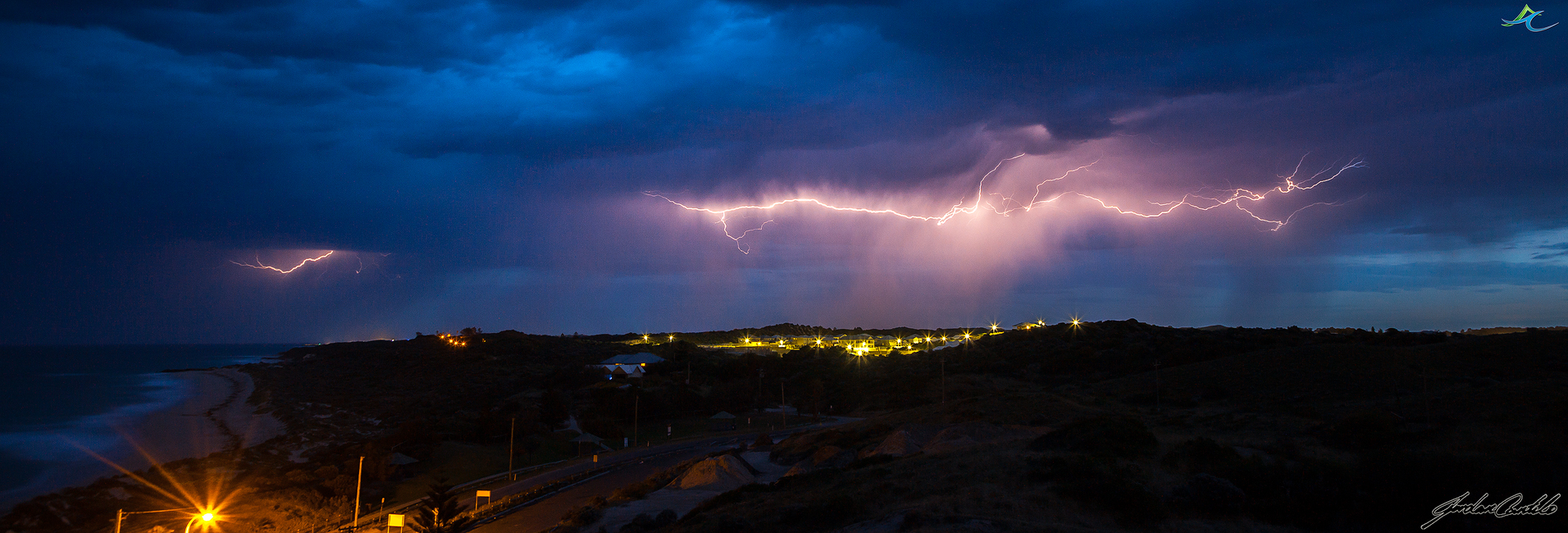
My time-lapse finished, I packed my gear up and raced east towards Latham.
I kept my eyes on the development, and I had to pull over near Latham to capture one of the storms.

_MG_8377

As I got to Latham, I had to turn south and now head towards Wubin for fuel, and to meet with fellow storm chaser and friend Steve Brooks (owner of Perth Weather Live, http://www.perthweatherlive.com).

I arrived in Wubin, and met with Steve. He had been watching the cells to the north as well, so with a quick check of the radar to see the direction these cells were going, we saw that they were going to cross well south of Paynes Find to the north, and so the decision was made to get north, and find a spot to set up and capture these systems as they passed us by.

While we were driving the sun started to set and the thunderclouds become illuminated with incredible colours. It was incredible to witness. We were so focused to get to our spot that we missed the opportunity to capture the sunset at its best, but, we still still got a bit of colour and you can see that how it would’ve been incredible 5-10mins before hand.

_MG_8397

When we arrived at our location, we set up and started to capture the storms in the distance. One was to our North-East, one was t our North-West. Both were firing on all cylinders. Flashing, and sparking everywhere. Every second multiple strikes illuminated the clouds. So what did I do. I set up my time-lapse to capture it. I havent finished processing that yet, but when I do, I will post a link to the page it will be hosted on.

_MG_8405

Then the night really began.

A shot of a meteor flying over first cells of the night to the north.

_MG_8696

As the first cells passed over and headed east, the skies to the west now started to light up. Cells were quickly developing to our west, and were going nuts!!

A shot of the Milky Way with the storms firing underneath.

_MG_9063

Large amounts of rain mixed with hail were falling from incredible formations in the clouds.
Something about the structure I just love underneath thunderstorms.

_MG_9013

Lightning was all around

_MG_9076

One of the final cells that passed over before I had to make the long drive home.

_MG_9984

I had to leave, as I had to get back to Perth. The drive home was very eventful. Large hail, strong winds, lightning all around.

An extremely eventful night, but I am so glad I was able to witness it, and not on my own either. Cheers Steve, it was so great to have someone else there, yelling out as much as I was!! 🙂

I just hope this is an indication of a very active spring/summer storm season in the Midwest and Wheatbelt.

More photos to come.

Till next time.